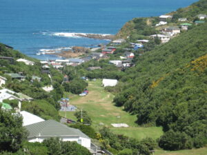
Haewai / Houghton Valley has a small catchment area with a high percentage of bush reserves, flat fields for recreation, and of course the beach at Houghton Bay, from which the official name of the suburb comes. The natural setting gives the area a country or holiday feel, despite being very close to the centre of Wellington.
However, the large amount of greenery masks a less environmentally sensitive history: as in other suburbs around Wellington, the place is a valley without a stream at the bottom of it, a natural anomaly. The bottom section of the formerly steep valley has been filled with landfill. The small creek running through it has been piped and covered over, and some of the springs that fed it have been buried.
Two decades of landfill
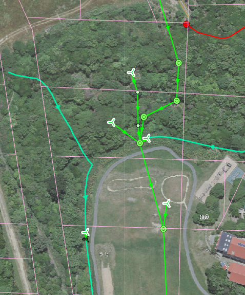
Planning for the landfill started in 1944 when the whole valley was mapped and the landfill designed. Detailed plans such as the one below show the original contours and the dump faces superimposed on top.
The landfill began in 1949, starting just below Hungerford Rd. The land was bare as it had been farmed for quite some time, so it didn’t take much to get started.
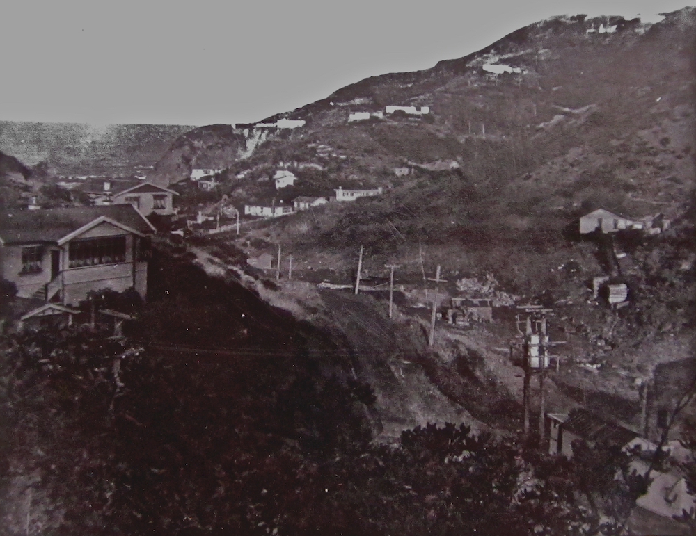
Landfill begins in the bottom of Houghton Valley
In the early 1950s the landfill continued up the valley to the school, where it was morphed into an earlier fill zone below the school that had been created for playing fields.
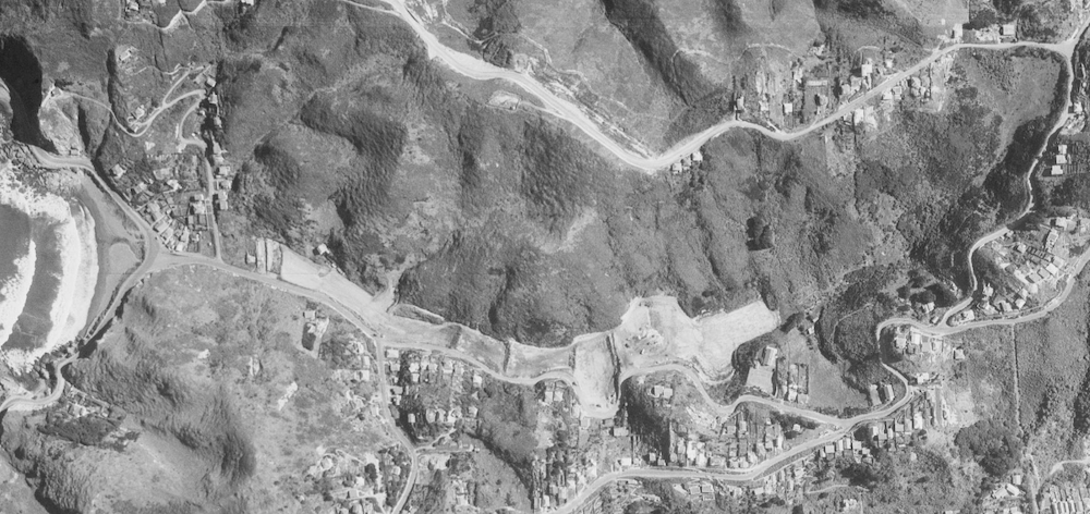
The first stage of landfill in Houghton Valley
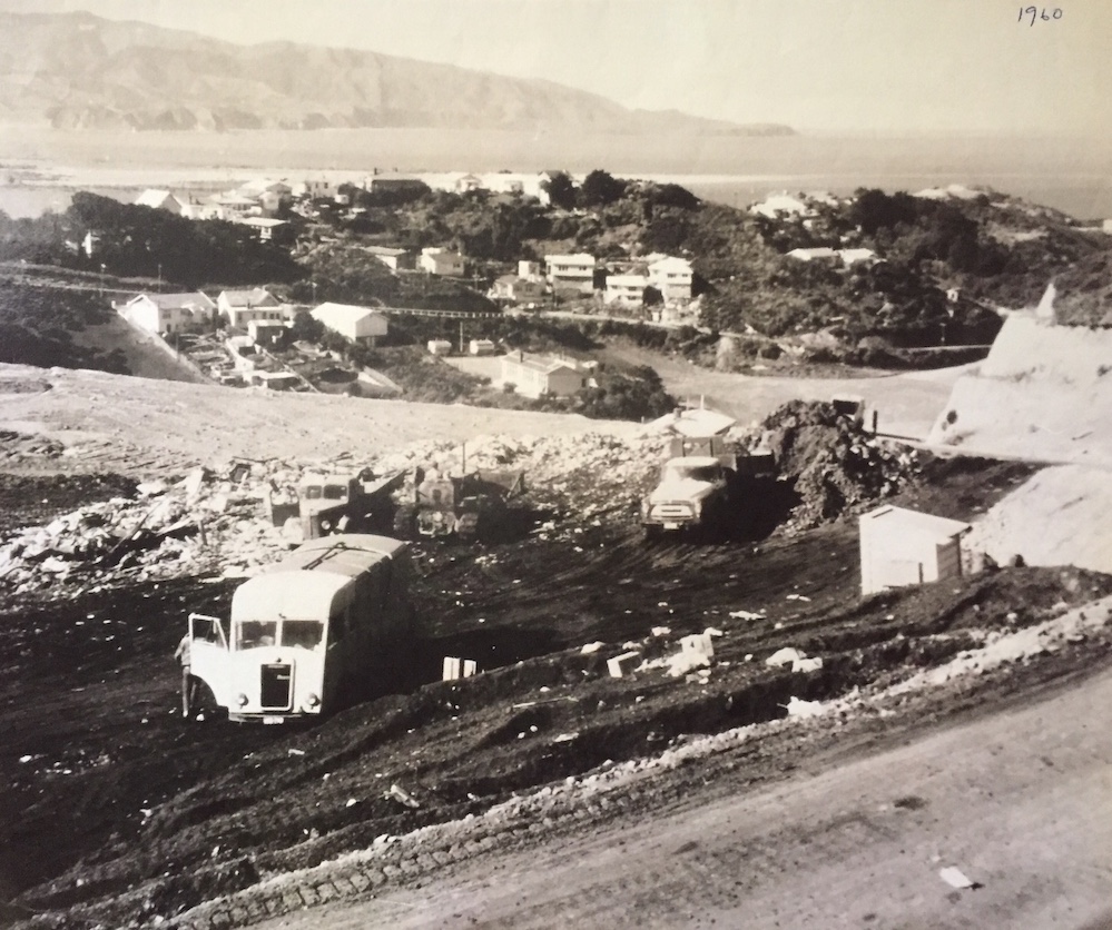
Then through the latter part of the 1950s and the 1960s until 1971 the landfill above the school was completed.
The upper landfill area (now Sinclair Park) in progress in 1960
The lost creek came back into shared community consciousness in two ways.
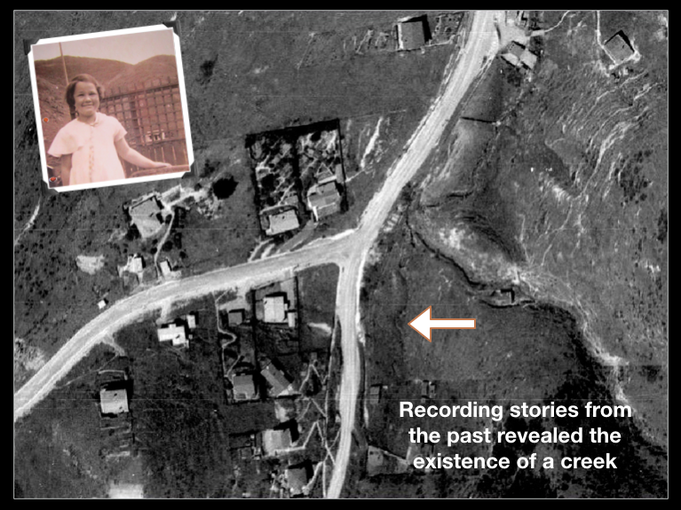
In 2010, Grant of Hungerford Rd started a PhD thesis with the aim of reinvigorating the local community to help it cope with an uncertain future. He started with a letter-box drop asking people what they knew about the history of the valley and what they would like to see for its future. He interviewed over 80 residents, and one of the older residents mentioned that she had played in a creek as a child, about where the Buckley Reserve playground is now, before the valley was filled in with a rubbish tip. It was a revelation.
As the community started connecting together, Ian and Kate of Buckley Rd shared a dream they had that the small stream near the Buckley Reserve playground that is diverted to pipes under the landfill, could once again flow on the surface. This, along with the contribution of several other unburied springs would make a creditable water flow into the area Ian and Kate had been planting as a wetland.
These two discoveries fast evolved into the concept of Lifting the Creek; not just rescuing the open springs in the lower valley, but any stream water from further up as well. As the residents looked into the whole infrastructure system, it became clear that all the valley’s stormwater and overland water from the hillsides was also entering the pipes and becoming needlessly contaminated.
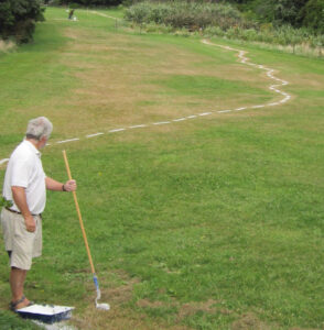
In February 2012 the creek returned symbolically as a 250 metre mown and white-painted strip, a feature of a community organised archaeological dig. The line traced the original bed of the creek, and seeing it painted on the surface of the landfill not only introduced others in the community to its existence underground, but produced quite heart-felt emotions in many.
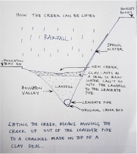
The concept for Lifting the Creek is not the same as daylighting a stream. Some of the pipes are up to 20 m underground, and removing the whole landfill to cart away and destroy another landscape is not the intention.
Water from just the western hillside after heavy rain
Lifting the Creek is about creating a new stream channel on the surface of the landfill. There may be some buried springs that sadly we can never recover, but we are able to keep rain water from entering the landfill and becoming contaminated by capping the landfill with a waterproof clay layer. We can contour the new layer to allow the surface water to flow towards and down a stream channel. The stormwater pipes from the houses and roads can also be directed to this stream channel. Wetlands at several places up the valley can help regulate the water flow from almost nothing in dry spells to a torrent during heavy rain. The wetlands can also provide moist habitat for wildlife when the general flow has stopped.
This concept is basically a natural stormwater management system, which is now a much more common and well-tested solution for urban areas as piped infrastructure fails to cope with greater demand and heavier rain events.
The diagram below shows a cross section through the landfill and the general concept.
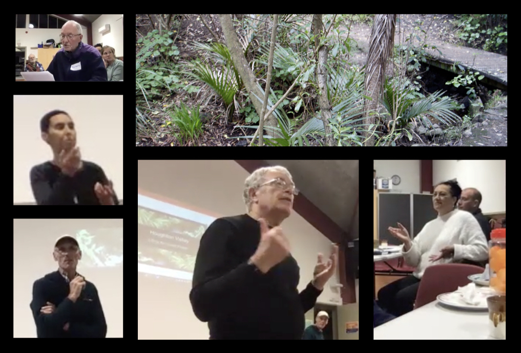
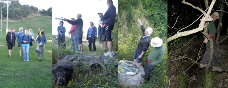
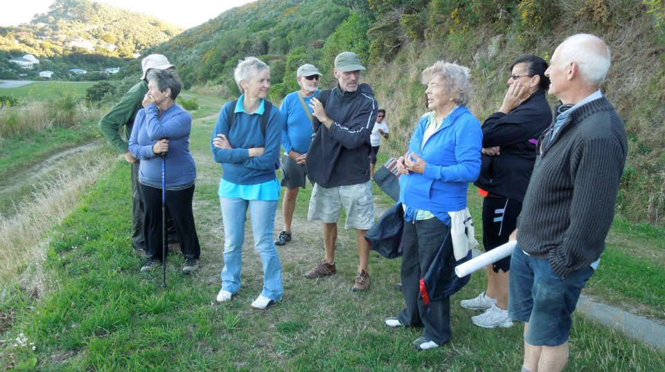
In February, the community organised an evening creek walk to explore Houghton Valley’s (very hidden) waterways and share everything they knew about the creek and the landfill drainage system. They met at the Sinclair Park Playground at the top of the valley, and following the line of the original creek as closely as possible, they worked their way down to the Buckley Reserve Playground, where it got a bit dark to go any further.
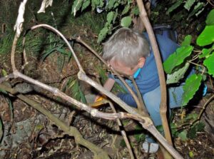
On the way they found the manhole lids that indicated the pipe network, the places where water was directed from channels into the pipes, and the freshwater springs.
The idea was to share the local history and what Lifting the Creek could mean, with the objective of coming up with a shared vision. It was not about the details of how it could be achieved, but what we as a community would like to see eventually.
Dave of Houghton Bay Rd was very knowledgable about the pipe network and brought maps of the system and described many happenings, including the time in the early 2000s when the pipe near the school field blocked and the school field flooded about half a metre as there is no other drainage to that area (the lower field is 1m higher than it).
Grant from Hungerford Rd and Jenny from Houghton Bay Road showed the others the secret channels and springs: there are nine all together including the larger stream that runs beside the track from Buckley Reserve Playground up to Buckley Rd, and one that supplies water for the Meadery.
2023
In November we had another community Creek Walk, called Haewai Creek Walk – Reimagining Houghton Valley. This walk focussed more on discussing / explaining / visualising our project for Lifting the Creek and remediating the problems of our closed landfill.
We had a pleasant ramble down the valley, exploring the various places that our catchment water makes it appearance, its way, and its disappearance down the valley. At times we had to revert to walking down the road due to swampy parts and steep places, though an intrepid few clambered down a gully formed by rainwater. We finished with a picnic afternoon tea at the playground.
We also created a Haewai Creek Walk handout with some of the background to the project.
Future hīkoi
Walks down the valley are an excellent way of understanding the landscape, the technical issues and the aspirations of the community. It is also a way of connecting emotionally with what has happened and what this place could become. In the development of the catchment design we hope to have more hīkoi to help align the stakeholders and consultants involved in the process. Although we need to find a way of covering the whole ground without running out of time or steam!
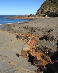
Rust (and no doubt other) contaminated water on Houghton Bay beach
One of Wellington’s earliest landfills, the Houghton Valley design was pretty primitive by today’s standards, with no lining, and covered with varied and sometimes minimal capping that wasn’t particularly waterproof. The pipe network under the rubbish was designed to capture the original creek water, water from the freshwater springs, overland water from the hillsides and stormwater from the roads (and hence the houses, which disperse their water directly onto the street).
Whether the pipes were meant to capture leachate or not, the water that seeps into the fill area and collects heavy metals and a large quantity of iron, also ends up in the pipes. During low flow, the water in the pipes is diverted to the sewer, but 30 mm of rain will cause the flow to overtop the jumping weir system and it is directed into the sea at Houghton Bay, now part of the Tapu Te Ranga Marine Reserve.
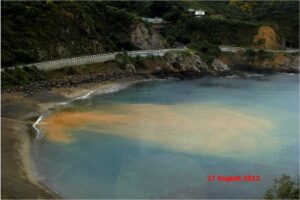
Rust plume in Houghton Bay
As well as visibly contaminated water flowing from the outlet at Houghton Bay beach at times, great plumes of water can be seen usually just after the rain begins after a settled dry spell. The timing of these plumes is a bit of a mystery – there is usually not enough water to overtop the weir. A possible explanation is that extra water from the Cave Rd spring and stormwater drains below the weir sends down enough water to stir up the sediment in Houghton Bay and discolour the water. Needless to say, surfers in Houghton Bay have reported rashes after swimming there.
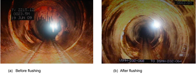
A programme implemented by Capacity (now Wellington Water) involves a 6-monthly flushing of the pipe network to remove encrustations. This doesn’t seem to have solved the problem.
From a 2013 report by Capacity water infrastructure services
Making a noise
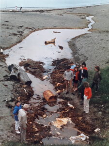
Leachate problems in 1989
In a newly surfaced box of archive material we found a picture of residents showing Councillor John Gilberthorpe the leachate problem back in 1989. Accompanying correspondence indicates that residents have been trying to get the issue fixed since the early 1970s. Back in February 1978, the Houghton Valley Progressive Association minutes recorded that the Parks and Reserves Department be asked to bulldoze the beach to clear the outfall of leachate from the tip. A long time resident also commented that at one stage they had to dig a channel from a naturally formed lagoon that was badly contaminated. It seems that a proper solution has always been deemed too expensive. The situation has been improved over the years, but then standards have gone up at the same time. The problem isn’t fixed yet. Below is a sample of more recent protests about the leachate.
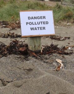
John of Island Bay often walked along the South Coast towards Houghton Bay and was very vocal about any leachate that he saw. He said:
“My own active interest in the continuing intermittent flow of noxious leachate across the swimming beach at Houghton Bay, within the Taputeranga Marine Reserve began with an email to the WCC Mayor a year ago, on August 17, 2012, when there was a particularly foul discharge.”
He was very frustrated by the lack of response or action by the Council and took the story to The Dominion Post. John inspired locals to make more of a fuss, and to put up a sign by the outfall warning people of the polluted water, as he often saw children playing near it. In the meantime he put up a small laminated sign saying, “Danger Polluted Water”, which Capacity promptly removed. Read the full story here.
In February 2013, a group of locals arranged to meet with the City Council to present the issue of leachate going onto the beach from the old landfill and what to do about it. Although not much really eventuated from the meeting, one of the locals provided some very graphic photos, which are now featured under Leachate on this website.
There may well have been more, but you probably get the picture!
Hydrocarbon Odours
Another consequence of the leachate and/or organic material getting trapped in the system and rotting is the formation of hydrocarbon odours. These not only come out at the beach, but emanate from the stormwater drains around the valley and enter into residents’ homes, making life very unpleasant at times. The worst odours seem to be in the vicinity of Hungerford Rd. Separating the stormwater from the leachate pipe would solve this issue.
A group of local creatives got together in early 2014 to work towards making a presentation at an online international symposium on water, called Waterwheel World Water Day, about the community’s Lifting the Creek project. They each explored their response to the project, what the creek meant to them and what they would like to see happen. They had weekly meetings to generate and develop ideas and work on a combined presentation.
Their contribution to the symposium was on the evening of March 21. It was called Putawai: Lifting the Creek. (Putawai translates as the appearance of water.) Hard to imagine now, but back then creating an online symposium was quite an undertaking, and the presentations were restricted to a very small number of megabytes. Some of the original presentations have been lost but below is a sample of what we have managed to preserve.
Postcards to the Creek
Jan and Ella of Hungerford Rd dreamed up an idea called Postcards to the Creek. Postcards were printed and distributed around Houghton Valley and at the school asking people to write a message to the creek in Houghton Valley. The mail box was placed near the small spring opposite the Buckley Reserve Playground for two weeks, and postcards could be mailed there. Over 50 postcards, many from children, with written and drawn personal responses included enthusiasm about the idea of lifting the creek, remembering its past health, the importance of a clean environment, and imaginings of the future clean creek and thriving wildlife.
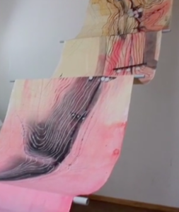
Flow Chart
Andrea of View Rd created an installation called Flow Chart. She used the original contoured maps with the landfill design, highlighted and coloured with litmus-like chemical reaction colours. The maps were presented in a continuous stream-like structure. Geoff of Melrose Rd created a video of the individual maps, creating a stream-like presentation through video and audio, as well as documenting Andrea’s installation opening where she invited the community to view it. It was later expanded and installed as an Urban Dream Brokerage project.
Jenny of Houghton Bay Road dreamed of creating a shared story for the community. Modern neighbourhoods have lost their sense of history – stories of the past – and are unable to connect with each other to share stories of the present. Her project looked at creating a shared story for the future. The story is set as a children’s story as the simplicity of this genre is closer to the myths of old. In her illustrated excerpt, conversations with the stream create a much deeper connection with the nature of water, something that people might fail to see otherwise.
Miranda of Hornsey Rd created an installation of secondhand teapots buried in the spring near the Buckley Reserve Playground, which we afterwards affectionally called Teapot Creek. We wrote offerings to the creek and put them in the teapots. Geoff once again created a great video of the tea ceremony.
Dave of Houghton Bay Rd had over the years collected an amazing collection of photos of the view from his house towards Pencarrow Head and the variety of weather conditions, caused by that greatest of greenhouse gases – water. Geoff dramatised the photos in another match of pictures and music.
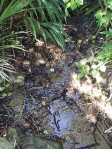
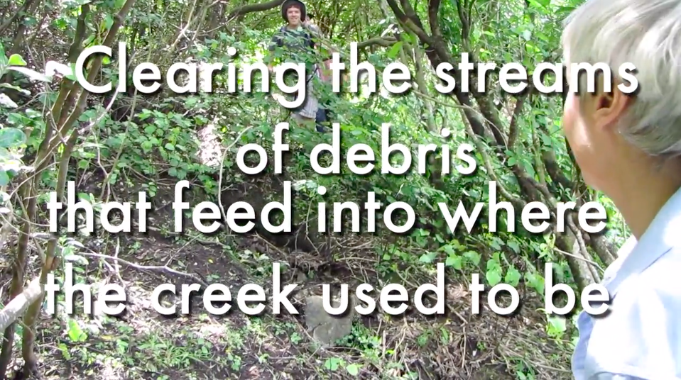
This was a collaborative project started by Jenny of Hungerford Rd to create awareness within the community of the existing freshwater streams in our valley, by weeding and clearing the channels, restoring the bush and creating tracks for people to visit the springs.
As her symposium presentation she reflected: “We are trying to explore a different way of caring for common lands, one that is more akin to indigenous feelings of guardianship. Firstly is to understand that it doesn’t have to be only the job of the authorities: that people can connect with public reserves and look after them the way they would look after their own garden. We have begun to do this in our valley.
Through several sessions we have begun to realise that guardianship works on a deeper level than mere well-meaning working bees. There needs to be a sense of reverence towards the place one is working in, and then the act of tending is more spiritually rewarding, a deeper connection is made. People need also to change the way they perceive the act of caring: it isn’t a duty to be done, it isn’t a time of personal therapy, it isn’t a way of planting your own idea of what is right on the landscape. Having reverence means that you enter the natural world in an open frame of mind. By absorbing the world around you, by noticing and listening to how it is, you can begin to understand what – if anything – needs to be done. Like a child you can be accepting of natural chaos, of what is right, but as an informed adult you can be discerning of the false notes: the rubbish, the blocked energy, the plant species that don’t belong. By entering into the world completely and with all senses receptive to what is around you, you are able for the moment to become the stream, the plants and the wildlife. And by becoming, you can truly understand what is needed.
A spiritual connection with a place does involve some aesthetic intervention as with the spring shrines of old. You naturally wish to enhance the good energy as well as clearing the bad. After removing the weeds, you need to look at what is left – sometimes very little – and introduce more of the right plants to replace them. By studying and understanding the parts that do work, you can replicate that energy by planting the right species in the right place. By creating places for people to appreciate the world they have entered – special views, sitting spaces, tracks, ways to get down to the water – you can create a meaningful interaction between the environment and visitors, and keep them from trampling indiscriminately. The water itself needs to be treated sensitively, understanding natural patterns of channels and pools and leaf litter build-up, and respecting the often hidden wildlife that is there. Clearing excessive debris will enhance the visual impact of the stream; clearing too much could destroy a habitat. Similarly with the bush, open spaces may be more beautiful to a person, but may not be right for the plants or the water.”
Geoff created a video of one of the spring clearing sessions.
Putawai was also our translation for the concept of Becoming Creek, which was an underlying theme for the Waterwheel presentation. Becoming Creek refers to a process, a transition from humans as a dominant species to becoming humans that co-habit with all species. Equity and respect would be a guiding principle. An example is the Whanganui River, which has the same legal rights as a human. In the Haewai / houghton Valley community, Becoming Creek is unfolding at the same time as the lifting of the creek becomes a reality.
And in word play, Becoming Creek can also apply in several ways:
Becoming Creek: the water that drop by drop and trickle joining into trickle down the hills becomes a creek in the bottom of the valley;
Becoming Creek: the lost creek that the people in the valley wish to bring back is becoming a reality, initially in imagination and eventually in truth;
Becoming Creek: the creek that is beautiful;
Becoming Creek: the people in the valley are collectively identifying with the creek and the distinctions between the community and the creek are dissolving.
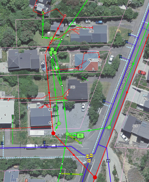
What do we know about the pipe network and how it works? Answer: not everything. But over the last decade we have certainly increased our understanding of how it works. We know that the pipe under the landfill takes water from the springs, overland water from the hills and stormwater from the road. The water is contaminated by leachate from the tip, but we don’t know if that is intentionally or only through cracks in the ageing pipe structure.
The following are three parts of the system that have posed much head scratching and thought for quite some time, although the last (possibly) shows a welcome development.
Piping the Creek
The main (green) pipes come to and end, what does that signify?
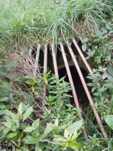
When they first started the landfill, they had to put the small creek they were covering into a pipe. The largest nearby spring was also directed into the pipe, the other springs must have been deemed not sufficiently large to bother with. And that is the interesting point: as you work up the valley putting the water in the pipe, the quantity of water gradually gets smaller, because that is what streams do. So at what point do you stop the pipe, because if you go too far the water can’t get in! Looking at the maps there is a point just above the school where the main pipes stop, and a stormwater pipe enters from the side.
What too are the little propellor shapes, are they vents? (No surface evidence of that.) Are they there to let spring water in or leachate? Maybe one day someone might have the answer for us.
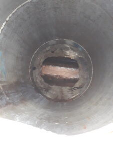
The Jumping Weir
Low water flow is diverted to the sewer, high water flow goes to the beach
The jumping weir is a system designed to divert leachate from the landfill into the sewer during low water flow, but to allow it to overflow into the stormwater system (and hence onto the beach) during heavy rainfall events (anything over 30 mm). The jumping weir consists of the three green close together manhole lids shown in the photo.
Given the increasing number of heavy rainfall events now, this means that the frequency of contaminated water entering the marine reserve is much higher. But the system has never worked completely effectively.
Sarah Free visited the Houghton Valley Community Gardens in 2013, just before she was elected as Ward Councillor for Wellington City Council. It was there that she first learnt about the Lifting the Creek project. She published a post on her blog about the visit.
Sarah managed to get the WCC staff interested in the project and in August 2014 they asked the Houghton Valley Progressive Association to hold a public meeting to discuss initiatives to eliminate pollution in the Bay from the old tip and lift the creek that currently flows through a pipe under it. As well as 35 locals, Sarah Free, Paul Eagle and four Council staff also attended. The Council infrastructure director outlined a partnership proposal that would see the community join with staff to work on the feasibility study (using a landfill fund of about $35,000), to be completed by the end of the year.
Later, 10 locals met with Council Staff to agree on a vision, and to produce a high level investigation brief. Once that was done the Council engaged Cardno Consultants to evaluate and develop the proposed remediation. The idea was that the work would be completed in time for the results to be integrated into the Council’s long-term plan. At another meeting at the community garden Cardno Consultants presented a detailed plan for Lifting the Creek.
After one more meeting where we asked about the progress of the project getting into the Long term Plan, the whole thing went quiet. It obviously didn’t get in, and it wasn’t until a long time later that we heard that there were at least two other landfills with a higher priority.
However, in a recent chat with Sarah Free, she said the only thing on her ‘to do’ list that she created back in 2013 that she hadn’t achieved was the Lifting the Creek project. So she may still be keen to see it through, even though she hinted that an entire clean-up of the coast, including Owhiro bay and Moa Point really needed to be addressed.
Looking down one of the man-holes to a rust coloured flow of water
In 2020, three locals conducted an e-DNA sample of our local stream near the Buckley Reserve Playground as well as the water in the pipe under the landfill.
The sampling produced some encouraging results. Not only are there Kōura (freshwater crayfish), which we already knew about from sighting them, but there were signs of a native fish, the banded kōkopu. These creatures are surviving in our very fresh but only inches deep spring water, cut off for 70+ years by the landfill pipes.
Not surprisingly, the results found no fish life in the stream once it had entered the pipes below the landfill.
In 2021, through a series of meetings held by locals to brainstorm ideas for the valley, one of the group suggested we contact our Whaitua Committee about our Lifting the Creek project.
We found out that Whaitua (catchment) Committees recommend ways to maintain and improve the quality of fresh water for Regional Council, and help to achieve a community vision for water by combining mātauranga Māori, citizen science, community knowledge, and expert information. The committees then develop a Whaitua Implementation Programme together with their communities, which describes community aspirations for freshwater and helps set a platform for collective effort to improve the health of waterways. The plan is implemented through new regulations and actions on the ground. It sounded perfect!
In April, locals welcomed the Whaitua te Whanganui-a-Tara and other interested water restoration groups to an evening of shared aspirations and conversations about how to restore the Houghton Valley water catchment.
The evening started at the playground near Hungerford Road and the manuhiri were welcomed with a mihi, karakia and waiata. The guests were then invited to ‘cross over’ the stream beneath. Then after some introductions, there was a quick tour of the local springs and wetland before everyone headed up to the school hall for some kai, presentations and discussions.
The evening was very positive and they fully supported the project in principle, but in the end the committee was not able to make any recommendations as streams in pipes were not recognised by the Resource Management Act, something which is now being remedied. However, they suggested we try again to get the project into the next WCC Long Term Plan, which we are currently, if not slightly belatedly, trying to do.
 Haewai / Houghton Valley has a small catchment area with a high percentage of bush reserves, flat fields for recreation, and of course the beach at Houghton Bay, from which the official name of the suburb comes. The natural setting gives the area a country or holiday feel, despite being very close to the centre of Wellington.
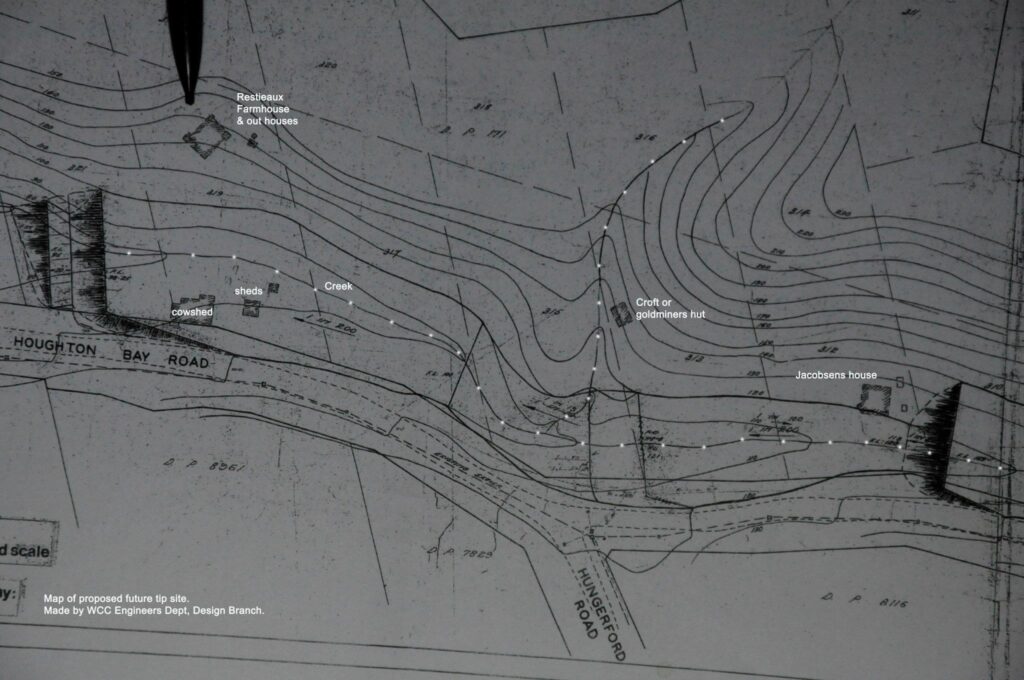
 In February 2012 the creek returned symbolically as a 250 metre mown and white-painted strip, a feature of a community organised archaeological dig. The line traced the original bed of the creek, and seeing it painted on the surface of the landfill not only introduced others in the community to its existence underground, but produced quite heart-felt emotions in many.
 Grant from Hungerford Rd and Jenny from Houghton Bay Road showed the others the secret channels and springs: there are nine all together including the larger stream that runs beside the track from Buckley Reserve Playground up to Buckley Rd, and one that supplies water for the Meadery.
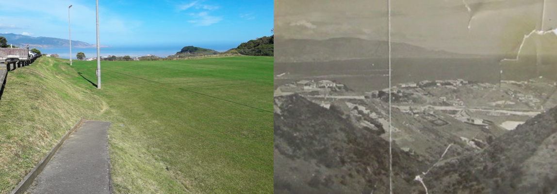
 John of Island Bay often walked along the South Coast towards Houghton Bay and was very vocal about any leachate that he saw. He said:
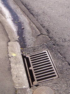
 A group of local creatives got together in early 2014 to work towards making a presentation at an online international symposium on water, called Waterwheel World Water Day, about the community’s Lifting the Creek project. They each explored their response to the project, what the creek meant to them and what they would like to see happen. They had weekly meetings to generate and develop ideas and work on a combined presentation.
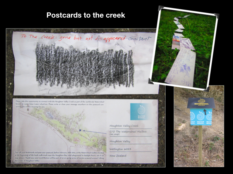
 Andrea of View Rd created an installation called Flow Chart. She used the original contoured maps with the landfill design, highlighted and coloured with litmus-like chemical reaction colours. The maps were presented in a continuous stream-like structure. Geoff of Melrose Rd created a video of the individual maps, creating a stream-like presentation through video and audio, as well as documenting Andrea’s installation opening where she invited the community to view it. It was later expanded and installed as an
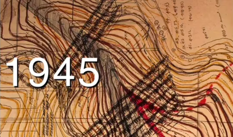
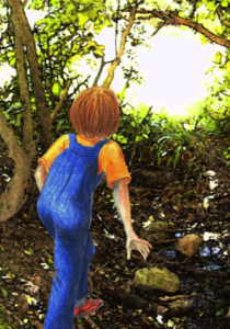 Jenny of Houghton Bay Road dreamed of creating a shared story for the community. Modern neighbourhoods have lost their sense of history – stories of the past – and are unable to connect with each other to share stories of the present. Her project looked at creating a shared story for the future. The story is set as a children’s story as the simplicity of this genre is closer to the myths of old. In her illustrated excerpt, conversations with the stream create a much deeper connection with the nature of water, something that people might fail to see otherwise.
 Miranda of Hornsey Rd created an installation of secondhand teapots buried in the spring near the Buckley Reserve Playground, which we afterwards affectionally called Teapot Creek. We wrote offerings to the creek and put them in the teapots. Geoff once again created a great video of the tea ceremony.
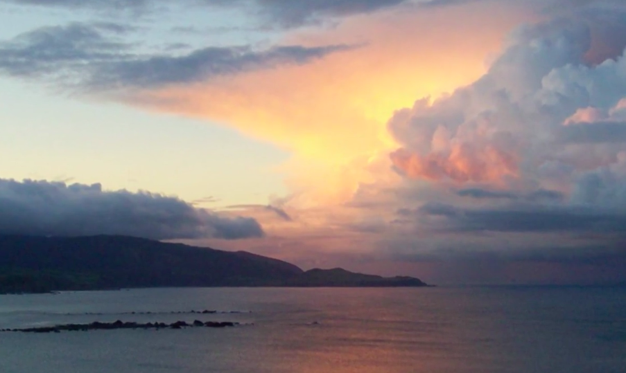
 Sarah Free visited the Houghton Valley Community Gardens in 2013, just before she was elected as Ward Councillor for Wellington City Council. It was there that she first learnt about the Lifting the Creek project. She published a
  Later, 10 locals met with Council Staff to agree on a vision, and to produce a high level